
Aaj Ka Mausam (8 June 2026): Uttarakhand Meteorological Center Issues Extended 6-Day Rainfall Forecast Till June 13; Temperatures Set to Rise 4°C to 6°C Across the State
The mountainous weather dynamics of the Western Himalayas are transitioning into a sustained wet spell. According to the comprehensive Uttarakhand weather forecast officially released by the Meteorological Center Dehradun, the state is tracking an extended 6-day rain and thunderstorm cycle starting today, Monday, June 8, and continuing through June 13.
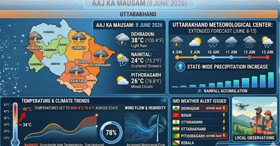
Delhi News info Desk: While specific upper hilly districts face immediate, recurring precipitation zones, the lower plains will witness a brief dry phase accompanied by a sharp, temporary surge in daytime temperatures before receiving full monsoonal relief.
1. High-Altitude Breakdown: 5 Hilly Districts on Active Alert
The IMD weather update indicates that light to moderate convective activity is immediately taking root along the higher ridges of the state.
-
The Active Zone (June 8 — June 10): For the first 72 hours of this cycle, weather systems will remain highly concentrated across five primary mountain districts. Garhwal's Uttarkashi, Chamoli, and Rudraprayag, alongside Kumaon's Bageshwar and Pithoragarh, are under a rolling warning for scattered showers, mid-level cloud development, and sudden localized thunderstorms.
-
The Plains Outlook: Concurrently, lower-altitude plains districts—including Haridwar and Udham Singh Nagar—will experience mostly dry, stable conditions with clear skies through Wednesday.
2. Multi-Day Chronology: How the Storm System Will Shift
The regional meteorological chart details a distinct spatial expansion of rain across both the Garhwal and Kumaon divisions as the week progresses.
Localized Mountain Showers
June 8 — June 9
Rainfall remains restricted exclusively to the upper alpine heights of five districts (Uttarkashi, Chamoli, Rudraprayag, Bageshwar, Pithoragarh). Remaining areas stay dry.
System Consolidation
June 10
Precipitation structures begin expanding slowly into mid-altitude hills, bringing sudden late-evening wind gusts and lightning cells.
Shift toward Kumaon Division
June 11
Rainfall systems intensify significantly over the Kumaon region. Districts like Almora, Nainital, and Champawat join Bageshwar and Pithoragarh in tracking moderate downpours, while the rest of the state transitions into very light showers.
State-Wide Precipitation Coverage
June 12 — June 13
The weather front achieves full state-wide coverage. Hilly districts will experience widespread rain and thunder-showers, while the plain corridors of Haridwar and Udham Singh Nagar will finally track light, cooling rain showers.
3. Critical Temperature Trends & Heat Advisory
While a long-term wet spell is locked in, the immediate short-term timeline features a paradoxical spike in heat.
-
Recent Cool Base: Over the past 24 hours, actual temperatures across Uttarakhand’s plains and hill stations sat substantially below historical seasonal averages due to early pre-monsoon squalls.
-
The 48-Hour Mercury Spike: The IMD warns that over the next 2 to 3 days, maximum temperatures across the state are projected to surge by 4°C to 6°C. This rapid thermal accumulation will trigger sudden afternoon heat spikes in major valleys like Dehradun and Haldwani before the system stabilizes ahead of the state-wide rain on June 11.
| Regional Hub | Base Level (Past 24 Hours) | Projected Max Temp (June 9-10) | Expected Relief Impact |
| Dehradun Valley | Considerably below normal | 36°C — 38°C | Thunder-squalls post-June 11 |
| Haridwar Plains | Below normal thresholds | 39°C — 41°C | Light scattered rain by June 12 |
| Nainital Foothills | Cool mountain base | 25°C — 27°C | Heavy rain systems active June 11 |
IMD Advisory for Char Dham Pilgrims: Travelers on the active Char Dham circuit (Kedarnath, Badrinath, Gangotri, Yamunotri) are strongly advised to keep a close eye on real-time localized weather updates. Sudden cloud-to-ground lightning developments, sharp drops in visibility, and high-velocity mountain wind gusts can create tricky transit conditions along narrow hill roads.