
Aaj Ka Mausam (8 June 2026): IMD Issues Severe Thunderstorm & Heavy Rain Alert for 21 States Including UP, Bihar, MP, and Chhattisgarh
A massive wave of pre-monsoon and monsoonal turbulence is sweeping across the nation. According to the IMD today weather update, a highly active atmospheric trough has triggered a sweeping thunderstorm alert across 21 states.
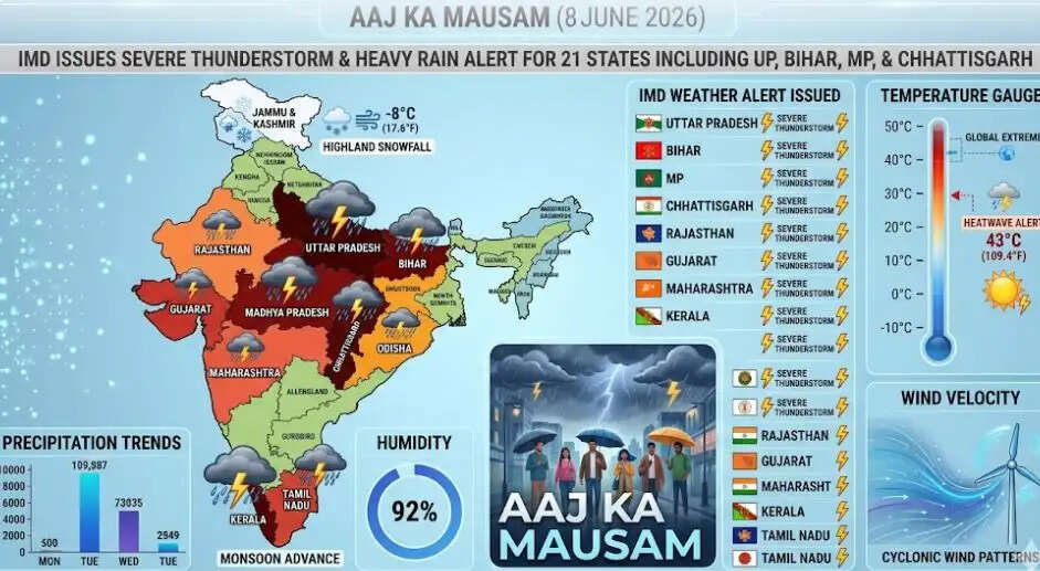
Delhi News Info Desk: While the core branch of the Southwest Monsoon expands its footprint across the southern and eastern parts of the country, intense convective cloud systems are sparking violent wind squalls, heavy lightning, and hail hazards down the center of the country.
1. Central India Alert: Severe Storms hit MP, Chhattisgarh, and Vidarbha
The central plains are bearing the brunt of the atmospheric collision between cold, moisture-rich monsoonal winds from the coast and residual continental heat.
-
High-Speed Squalls: Sudden wind storms hitting speeds between 50 to 60 km/h are tearing across Madhya Pradesh and Chhattisgarh. Authorities have warned of potential damage to temporary structures and minor disruptions to local power grids.
-
Dangerous Lightning Grid: Both states are under a high-frequency cloud-to-ground lightning warning. Locals have been strictly advised to seek permanent shelter immediately if thunder is heard.
2. East India Updates: Bihar and Jharkhand Tracking Heavy Rain
The monsoon heavy rain tracker reveals that eastern states are pulling in significant moisture from the Bay of Bengal branch.
-
Bihar Comfort Index: Rising atmospheric moisture is keeping real-feel temperatures extremely sticky and uncomfortable. However, widespread pre-monsoon rain clusters are expanding into northern Bihar, bringing a necessary drop in temperature.
-
Jharkhand Warning: High-velocity thunder-squalls are forecast across Ranchi and surrounding districts. The incoming precipitation will systematically ease the prolonged heatwave stress over the next 48 hours.
3. State-by-State Breakdown Across Key Zones
| State / Region | Primary Weather Threat | Active Wind Speeds | Expected Temperature Range |
| Uttar Pradesh (UP) | Severe East-West split; lightning alerts in the east, heatwave in the west. | 40 — 50 km/h gusts | 41°C — 44°C |
| Madhya Pradesh (MP) | Scattered hail hazards and localized intense rainfall blocks. | 50 — 60 km/h squalls | 38°C — 41°C |
| Chhattisgarh | Overcast conditions, frequent thunderstorms, and steady rain. | 40 — 50 km/h gusts | 36°C — 39°C |
4. North-Northwest India: Persistent Heatwave Before Peak Relief
In complete contrast to the active rain zones, the northwestern plains—including Delhi-NCR, Haryana, and West Rajasthan—are continuing to battle intense daytime Loo conditions under clear skies.
The Climate Lifeline: The IMD notes that the heatwave warnings governing the capital region will remain strict for the next 72 hours. However, the advancing multi-state rain system, combined with a fresh Western Disturbance (WD) scheduled to arrive on June 11, will merge to trigger widespread dust storms, rain showers, and a definitive drop in temperatures by the weekend.